Panoramic view from James's Hill, East Renfrewshire
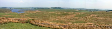
Looking North West from James's Hill, Harelaw Dam is on the left, the Neilston Pad is in the centre with the trees. To the right you can just see the houses of Neilston and on the extreme right is Glasgow. The ruined stone walls in the foreground are quite extensive and may have been used as sheep enclosures at some time. Map location.


![Panoramic view from James's Hill, East Renfrewshire
Looking North West from James's Hill, Harelaw Dam is on the left, the Neilston Pad is in the centre with the trees. To the right you can just see the houses of Neilston and on the extreme right is Glasgow. The ruined stone walls in the foreground are quite extensive and may have been used as sheep enclosures at some time. [url=http://www.streetmap.co.uk/map.srf?X=248695&Y=653210&A=Y&Z=115/] Map location. [/url]](albums/userpics/10001/normal_James_s_Hill_Panorama.jpg "Click to view full size image
==============
Panoramic view from James's Hill, East Renfrewshire
Looking North West from James's Hill, Harelaw Dam is on the left, the Neilston Pad is in the centre with the trees. To the right you can just see the houses of Neilston and on the extreme right is Glasgow. The ruined stone walls in the foreground are quite extensive and may have been used as sheep enclosures at some time. [url=http://www.streetmap.co.uk/map.srf?X=248695&Y=653210&A=Y&Z=115/] Map location. [/url]")