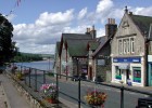
Said to be the gateway to Sutherland, Lairg developed in the early 19th century on the shores of Loch Shin. The level of the loch was raised by some 11 metres after the opening in 1959 of the Lairg Hydro power station which can be seen in the distance. Map location
Rate this file (Current rating : 1 / 5 with 1 votes)


![Main Street, Lairg, Sutherland
Said to be the gateway to Sutherland, Lairg developed in the early 19th century on the shores of Loch Shin. The level of the loch was raised by some 11 metres after the opening in 1959 of the Lairg Hydro power station which can be seen in the distance. [url=www.multimap.com/map/browse.cgi?lat=58.0237&lon=-4.4005&scale=5000&icon=x/]Map location[/url]](albums/userpics/10001/normal_Lairg%2C_Sutherland.jpg "Click to view full size image
==============
Main Street, Lairg, Sutherland
Said to be the gateway to Sutherland, Lairg developed in the early 19th century on the shores of Loch Shin. The level of the loch was raised by some 11 metres after the opening in 1959 of the Lairg Hydro power station which can be seen in the distance. [url=www.multimap.com/map/browse.cgi?lat=58.0237&lon=-4.4005&scale=5000&icon=x/]Map location[/url]")