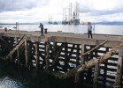
The Cromarty Firth forms a huge natural harbour area, it was used in the past as an anchorage by the Royal Navy. Today it is common to see Oil rigs of all sorts either laid up or undergoing re-fit. This particular one is a jack-up rig, when raised the legs tower some 560ft above the rig. Map location.


![GSF Galaxy III, Cromarty Firth, 2015
The Cromarty Firth forms a huge natural harbour area, it was used in the past as an anchorage by the Royal Navy. Today it is common to see Oil rigs of all sorts either laid up or undergoing re-fit. This particular one is a jack-up rig, when raised the legs tower some 560ft above the rig. [url=http://streetmap.co.uk/map.srf?X=277605&Y=866951&A=Y&Z=120/] Map location. [/url]](albums/userpics/10001/normal_gsf_galaxy_iii.jpg "Click to view full size image
==============
GSF Galaxy III, Cromarty Firth, 2015
The Cromarty Firth forms a huge natural harbour area, it was used in the past as an anchorage by the Royal Navy. Today it is common to see Oil rigs of all sorts either laid up or undergoing re-fit. This particular one is a jack-up rig, when raised the legs tower some 560ft above the rig. [url=http://streetmap.co.uk/map.srf?X=277605&Y=866951&A=Y&Z=120/] Map location. [/url]")